
Enjoying the Truckee River Water Trail
Are you a kayaker? Whitewater rafter? Do you enjoy fishing or tubing? Whether you’re ready for adventure or simply need to cool off on a hot summer day, you’ll find what you’re looking for along the Truckee River Water Trail.
The Truckee River Water Trail is a 121-mile water route along the entire length of the Truckee River, from Lake Tahoe to Wadsworth. As it flows through our communities, it winds past alpine forests, rocky canyons, residential neighborhoods, urban landscapes, and desert sage. Much of its length is highlighted on the Truckee River Recreation Map and Nevada Trail Finder – with marked public access, rapids, restrooms, and more!
Want to learn more about the Water Trail? We’ve put together this guide to the best spots to enjoy the river in Northern Nevada and California. This guide includes:
1. Where to Paddle & Tube the Truckee River Water Trail
2. When to Paddle the Truckee River
3. River Safety Tips & What to Bring on the Truckee River Water Trail
4. Fishing Along the Truckee River Water Trail
5. Boat Rentals + Guided Truckee River Rafting and Kayaking Trips
6. What’s Next? More Ways to Recreate Near the Truckee River

Where to Paddle & Tube the Truckee River Water Trail
The Truckee River offers a stunning variety of terrain to fit all interests and ability levels. The best spot to start – and end – your trip depends on your watercraft, the amount of water flowing in the river, and how steep a challenge you seek.
Lake Tahoe to Alpine Meadows:
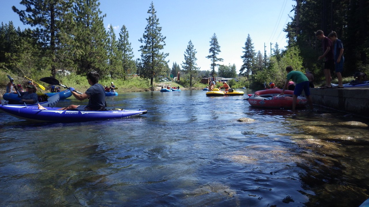
This family-friendly section is a great start for all ability levels. It’s a mellow Class I from start to finish, with a short Class II rapid you can opt out of just before River Ranch, at the Alpine Meadows turnoff. This popular rafting, kayaking, and inner-tubing reach is best when at least 100 cfs of water is being released from the small dam in Tahoe City.
Alpine Meadows to Town of Truckee (Donner Creek):
This Class II and III section of the Truckee River often feels boney but can run fast and refreshing during spring water releases. A minimum flow of 400 CFS is recommended, although it can be kayaked as low as 250 CFS. Above 1000 CFS, paddling the Truckee is illegal in Placer County due to hazardous low bridges. Prior experience with rocky whitewater is required. This is an Intermediate-to-Advanced level paddle for the section above Silver Creek Campground, with more Beginner-to-Intermediate friendly water downriver.
Truckee (Donner Creek) to Glenshire Bridge:
Consistent but approachable, this popular area offers a bit more challenge and risk for confident paddlers – without need to portage around dams and debris. Mostly Class II waters, with a brief Class III rapid at Truckee Falls that can be portaged if needed, make for an enjoyable afternoon along the Truckee River.
Glenshire Bridge to Old Boca Bridge:
This mostly Class II section is scenic and fun, but with some limited access. Long stretches of shoreline are privately owned, although taking in and out is permitted at the end of this section, near the mouth of the little Truckee River at Boca. From Glenshire Bridge to the I80 Bridge, the San Francisco Fly Fishing Club owns the river-right shoreline and prohibits public access. Artificial structures in the riverbed were built to create fish habitat and also provide enjoyable kayak surfing and small drop opportunities.
Old Boca Bridge to Floriston:
Steady Class III and IV features mark this section of the Truckee as a force to contend with. The rapids advance from Class II, to Class III, to a solid, difficult to portage Class IV for the last half mile. This section is only recommended with an experienced boater or guide to direct you around hazards. At flows above 1000 CFS, it becomes a IV+ (see Truckee River at Boca Bridge for flow information). You can take out at Floriston or continue down river. Commercial rafting outfitters (details below) offer group trips, running from Boca to Floriston or Crystal Peak Park, depending on the season. Click here for more information.
Floriston to Crystal Peak Park:
This is a III/IV run with 3 significant dams, up to 14 feet in slope. It’s a fun expert run that should be respected and approached with caution. There are opportunities to scout and portage all 3 of these dams. See the Truckee River at Farad for flow information. Click here for more information.
Crystal Peak Park to Mayberry Park:
This is a fun Intermediate-to-Advanced section of river with many boulders and challenging rapids to surf. It’s most enjoyable above 500 CFS in spring and early summer conditions. See the Truckee River at Farad for flow information. Click here for more information.
Mayberry Park To Wingfield Park:
When Northern Nevadans talk about floating the Truckee, this section is what it’s all about! While some minor rapids can be found, including a hazard at the abandoned diversion structure at Ambrose Park, and the low head dam at the Chalk Bluff water treatment plant, many tubers, kayakers, and rafters find this section just fast enough to be fun and exciting. We recommend tubers and casual paddlers take out at Idlewild Park or the Wingfield Whitewater Park. Beyond here, be wary of the Glendale Diversion Dam. See the Truckee River at Reno for flow information. Click here for more information.
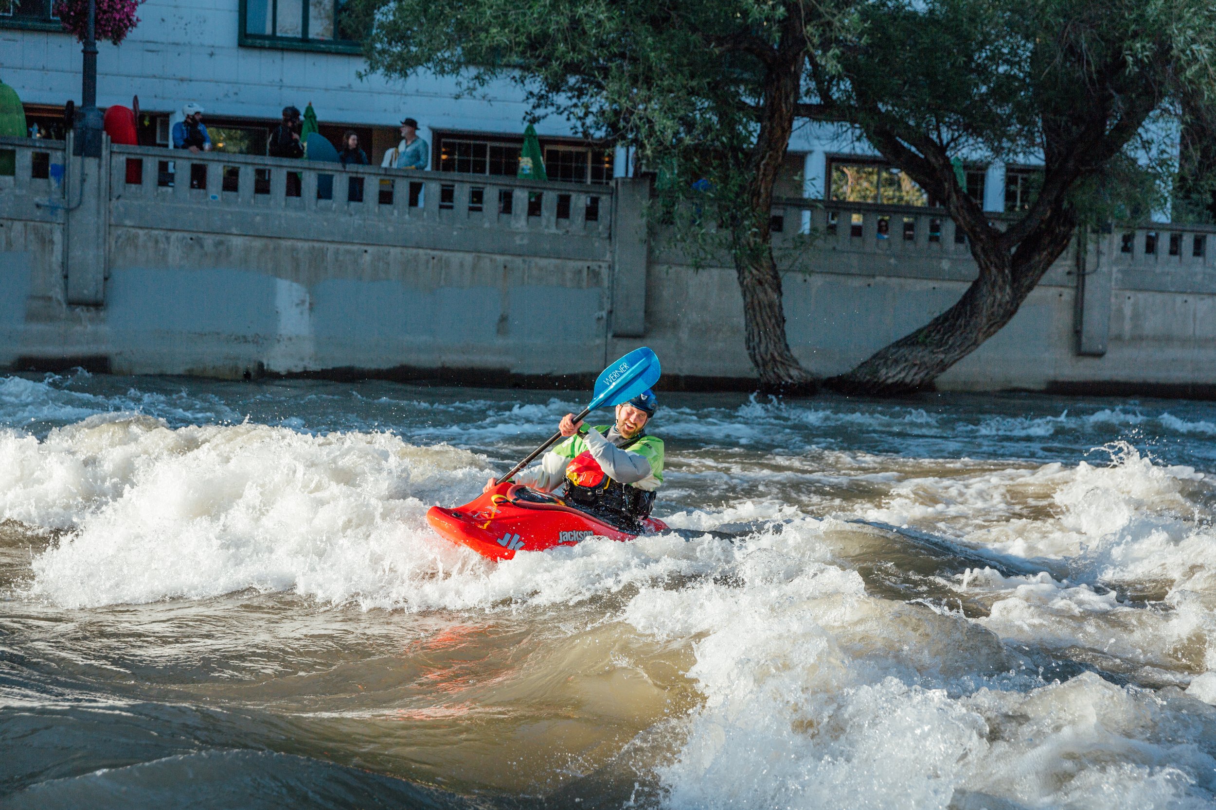
Wingfield Park:
Wingfield Park is a huge success story for river access and conservation. Until 2005, there were steep concrete walls on both sides of the water with no access to the river’s edge and a dangerous low-head dam on the left side. Today, Wingfield Park is an urban river paradise, presenting shoreline access to swimmers, tubers, and whitewater enthusiasts. Lifejackets are highly recommended. At Wingfield Park, you can run right or left of the island. Be aware of a diversion at the far right of the right channel. The left channel carries most of the flow and offers more powerful features. Scout before attempting. The right channel is easier. Sometimes, the right channel offers gates for practicing technique.
Wingfield Park to Rock Park:
This section includes a dangerous drop at the Glendale Dam that can only be averted via an easy-to-miss diversion. The dam should only be considered by experienced paddlers traveling with locally knowledgeable guides. Click here for more information.
Rock Park to Tracy:
Beyond Sparks, the Truckee calms and grows less traveled – but there’s still plenty to love about this section of the Water Trail. Past Steamboat Creek (Mile 62.74), be mindful of reduced water quality past the water treatment plant and sharp rocks in the water around mile 65.17. This section features small, rocky rapids just beyond Lagomarsino and easy-to-run in-river structures between Lockwood and Waltham Road. As you head away from town, you’ll experience a quick shift in terrain as the desert golds fade in. McCarran Park, river right (just past the Labor Union building) near Tracy, is a popular place to enter and exit the river, surrounded by cottonwood trees in a park restored by the Nature Conservancy.
Tracy to Wadsworth:
If you continue to paddle beyond the range of the Truckee River Recreation Map, you’ll encounter gentle Class I and II waters, easy-to-run manmade structures, and an environment that feels much-removed from downtown Reno and Sparks. Continue past USA Parkway, towards the steep concrete Derby Dam, and you’ll find lava rock formations in the middle of the river, popular features for locals to jump off on hot summer days. Take a break, and enjoy how far you’ve come. Wadsworth is the last legal take-out spot before the Truckee veers north onto land managed by the Pyramid Lake Paiute Tribe.
When to Paddle the Truckee River
The Truckee River and its tributaries are dammed in several areas and your on-river experience depends – a lot – on just how much water is flowing. For most sections, you’ll want to balance paddling when there’s enough water to avoid scraping on riverbed rocks, not too much flow so that your craft is difficult to control, and weather that’s warm enough for the Truckee’s snowmelt-fueled waters to feel refreshing.
On most sections of the Truckee, look for a minimum of 250 CFS, and ideally 400 CFS for a steady-moving trip. Whitewater enthusiasts get most excited about flows above 1000 or 1500 CFS. However, less experienced paddlers (and tubers!) should be cautious around these high water levels and consider rescheduling their trips, especially when releases run upwards of 1500 CFS on heavy snow years. The USGS website provides water discharge levels at several locations along the Truckee River Water Trail.
Show your appreciation for the Truckee River!

River Safety Tips & What to Bring on the Truckee River Water Trail
Especially when water levels are high, it’s important to keep safety in mind when you’re enjoying the Truckee River Water Trail. What do you need to know?
Be prepared. Know before you go. Check water release levels, understand how weather will affect snow melt, and review dams, debris, and other hazards along your route. Choose an appropriate route for your ability level and the current conditions.
Dress for safety. In cooler temps, opt for synthetic vs cotton fibers to stay warm. Consider wearing a wetsuit or drysuit. In summer, don’t forget sunscreen, sunhats, and other protective attire.
Gear up. Always wear a lifejacket, helmet, and closed-toe water shoes. Never paddle or tube alone, stay within sight of your crew, and understand the swimming abilities of everyone in your group.
Keep alcohol consumption in check. Alcohol and river recreation are poor mixers.
Know your coordinates. Check the river map and be ready for rapids and dams ahead. In case of emergency, note the mile marker signage (posted every tenth of a mile) along the river. Be prepared to let emergency services know where you’ve run into trouble.
Respect private property and pack out your trash. Appreciate that your good behavior on-river will enable future paddlers and tubers to continue to enjoy the Truckee River for years to come.

Fishing Along the Truckee River Water Trail
Did you know? Northern Nevadan anglers need not stray far from home. Several of our local parks offer excellent opportunities to catch Brown and Rainbow Trout. Crystal Peak, Mayberry, Oxbow, and Idlewild Parks are all fan-favorites, with the best fishing methods varying by season and water level. Visit Reno Fly Shop for guidance or to hire a pro – and don’t forget your Nevada fishing license!

Boat Rentals + Guided Truckee River Rafting and Kayaking Trips
Kayak rentals and guided Truckee River rafting trips are available in these communities along the Truckee River Water Trail:
Tahoe City
While this section is often floated independently, for those preferring a car shuttle and rental raft, Truckee River Raft offers support during peak summer months.
Truckee
For adventurers who prefer a true whitewater experience, Tributary Whitewater Tours, Isolated Rivers Incredible Experience, and Raft California all offer guided whitewater trips through some of the Truckee’s most exciting terrain.
Reno
Learn a new sport with Sierra Adventures. Located in downtown Reno, Sierra Adventures will get you caught up with the skills you’ll need to enjoy downtown Reno’s whitewater park, as well as any other rapids that peak your interest. Boat rentals are also available, for more experienced river travelers.

What’s Next? More Ways to Recreate Near the Truckee
Looking for riverside hikes, bike rides, and summer events? There’s just as many ways to enjoy the Truckee River’s shoreline out of the water as along the river itself. Keep reading for One Truckee River’s favorite things to do near our local waterway.